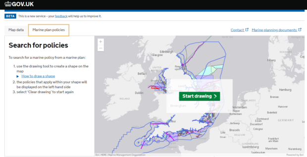
Our Explore Marine Plans digital service is now live! After nearly two years of user testing and development, Explore Marine Plans replaces the previous Marine Information System (MIS), delivering improved functionality for the user including spatially integrated Marine Plan policies, relevant data layers and Marine Licensing information.
MIS provided a means for users to interact with marine plan content and data and had been in service since 2015. Users were very positive about MIS, but highlighted there were improvements that could be made. In response to MIS feedback and ahead of the preparation of further marine plans around England, we were able to take advantage of European grant funding to develop a new and improved digital service. The ‘Discovery’ phase of the Digital Marine Plans Project started in late 2017, and worked with marine plan users to identify user journeys and requirements for a digital service. This confirmed the need to develop a new digital service.

In the next (‘Alpha’) phase, the findings and user research from ‘Discovery’ were used to develop and iterate through a series of sketch prototypes to test the user journey and functionality. During the ‘Beta’ phase, the preferred prototype was developed into a fully coded service, informed by further testing with users. Following a successful Government Digital Service (GDS) assessment, the new service Explore Marine Plans has now entered the public beta phase. MIS has been retired and redirects users to the new service.
Explore Marine Plans brings several benefits over MIS, including:
- an iterative, user-centred design and build process, focusing on identified user needs
- alignment with GDS design standards
- a single user journey through a streamlined, simpler service
Thank you to all those who have participated in user research across each phase of development. We will continue to collect feedback and enhance the service. For details on how to submit feedback, please contact the Planning mailbox directly.