Almost 8,500 ships of 300 tonnes or over went through English waters in a recent six-week study period.
That makes for an incredibly busy marine area, and the MMO needs to understand where commercial and passenger vessels are, so we can take this traffic into account as part of marine planning for our seas.
Marine planning work at the MMO considers a wide range of activities, industries, habitats and species, so being clear on where and when marine traffic is occurring, and also how many vessels are regularly in our waters, is essential.
We’ve developed a new system to understand how vessels use our seas, and found that in a study period including samples from all four seasons in the UK, 72% of the vessel transits passed through English waters, 20% through Scottish waters, around 6% through Welsh waters and 2% in Northern Irish waters. In all around 11,800 vessels called at or left UK ports, anchorages and ship-to-ship transfer areas. Our mapping is based on Automatic Identification System (AIS) data, which gives us a clear picture of marine vessel traffic. We have translated this into information more readily useable for marine planning. This is made possible via an open source tool – free to everyone and available on the MMO website – that will be used by other regulators working on marine planning across the UK, ensuring we’re all making use of data in a consistent way.
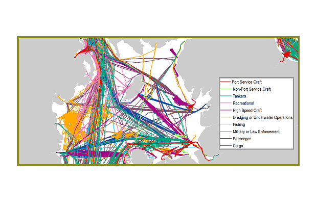
AIS signals are transmitted by most commercial and passenger ships. It tells us the position of a vessel and records are collected and managed by the Maritime and Coastguard Agency (MCA).
Our mapping joins individual vessel point positions together to form an easy-to-view transit line when joined together. We classify these by vessel type, and then look at the density of marine traffic.
The maps give you a really good idea of how busy our waters are with vessels, and you can visit the MMO’s marine planning portal to get a full picture of this for the South plan areas, alongside spatial information describing many other activities.
You can email us at evidence@marinemanagement.org.uk if you want more information about our evidence projects in general too.
Recent Comments