In summer 2023 we engaged with the fishing industry on fisheries mapping carried out by the MMO Marine Planning Team.
We’ve now incorporated stakeholder feedback through an update to the fisheries mapping work.
Amongst some of the key points you raised, we’ve addressed the following:
You Said
- Some areas that are considered locally important are not captured in the map using the methodology, which considers fishing nationally
- Mapping ICES rectangles along with hard constraints and existing structures would be useful, including wrecks
- It would be useful to break important areas down into fisheries, this could be per species or per fisheries area
- Using the top 80% of fishing activity may not capture changes in fisheries distribution arising from climate change induced shifts in fish populations over time, and similarly how other management measures would impact fishing distribution
- Context is required with the data and maps, so they aren’t misinterpreted
We did
- We mapped areas important to specific ports, and trialled mapping per marine plan area to understand how locality changes importance
- We uploaded fishing activity maps and ICES rectangles onto our digital marine planning service, Explore Marine Plans, to allow easy mapping of other activities alongside fishing activity maps
- We mapped fishing activity areas for both ports and per target species
- We started work on statistically validating the 80% cutoff, and continue to map the full range of fishing activity across the time series
- We’re providing further information, guidance and documentation alongside maps
In addition to actioning these valuable pieces of feedback, this new phase of fisheries mapping:
- Increased the time series of data used to include the most recent years of fisheries data to:
- Make use of the most recent available data from 2022 and 2023,
- Provide further insight into interannual variability in core areas,
- Assess how a longer time series influences important area size and how long a time series might need to be, and
- Improve understanding of inter-annual variability and their influence on important areas
- Applied a methodology for determining important areas for target fisheries species (Figure 1)
- Aligned analysed gear groupings with those used in the Cefas Fisheries Sensitivity Mapping and Displacement model (FiSMaDiM) for greater comparability
- Explored areas of local importance through examination of catch locations against their ports of landing (Figure 2)
- Tested the robustness of the assumptions made for the cut-off threshold (80%) for which an area is defined as a ‘core area’ for fishing
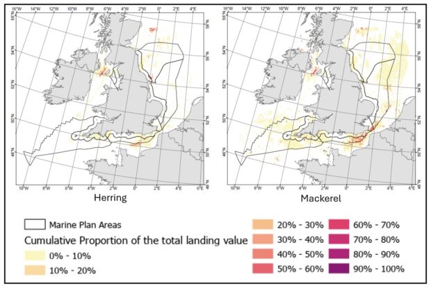
Figure 1. Spatial distribution of fishing activity for the UK over 12-metre fleet 2016-2023, visualised using the cumulative proportion of landing value across 2 target pelagic fish species: herring (left) and mackerel (right).
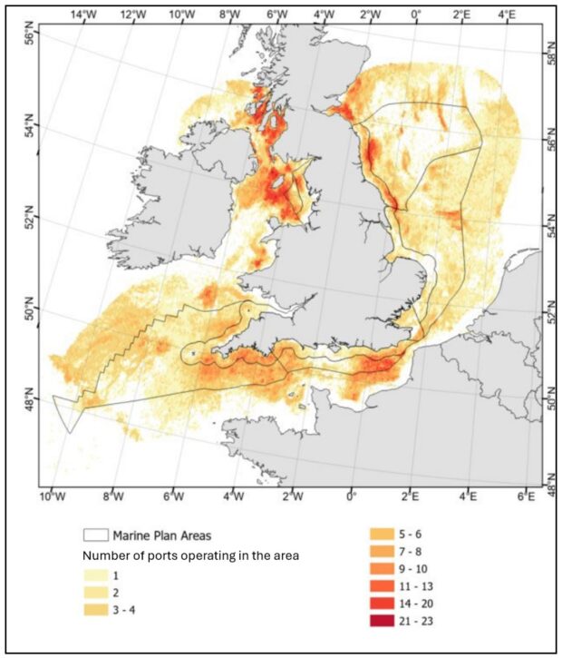
Figure 2. Map showing the number of ports operating around the UK based on fishing activity for the UK over 12-metre fleet 2016-2023.
Note that the UK under 12-metre fleet has not been analysed further in this phase, as currently available data is not at a resolution that would provide additional information beyond what was analysed in 2022.
The technical report, alongside a non-technical summary can be accessed via the Marine Management Organisation’s evidence register.
All the layers produced during this phase of work will be made available on our online marine planning service, Explore Marine Plans.
We are now seeking your feedback on the work carried out in this phase.
We have an open call for views through our online form, or you can contact us on the details below to discuss further.
The form can be accessed via: https://forms.office.com/e/TRA0nkjXL5
We thank you for any time taken to attend the sessions or fill out our survey.
We’d be happy to continue discussions with any interested stakeholders. Please get in touch via planning@marinemanagement.org.uk.